What Caused the Fall of Ancient Maya Civilization?
New discoveries suggest drought, warfare and poor political choices all played a role.

Mike Lovett
Charles Golden
by Jarret Bencks
Conventional wisdom has it that Maya kingdoms vanished into history following an agricultural crisis created by severe, prolonged drought.
But new research led by Brandeis anthropologist Charles Golden and Andrew Scherer, associate professor of anthropology at Brown University, found signs that communities in the Western Maya Lowlands of Chiapas, Mexico, likely had abundant crops when Maya civilization collapsed during the eighth and ninth centuries.
The research also shows the region’s three main kingdoms were each functioning in very different ways.
Using lidar, a remote sensing method that utilizes airborne lasers, the researchers were able to create a nearly complete picture of ancient ruins hidden to the naked eye beneath dense tree canopies. Their findings were published in October in the academic journal Remote Sensing.
“What we see is a story about variability,” Golden says. “The communities in this area were working and dealing with the challenges of drought, of warfare, of bad kings and good kings in very different ways. It shakes up our picture of who the Maya were.”
The research examined three valleys, each containing the capital of an independent kingdom, ancient cities known today as Piedras Negras, La Mar and Lacanja Tzeltal. Although archaeologists have closely studied parts of the region, the difficult terrain had left a great deal unknown.
Lidar mapping by the University of Houston’s National Center for Airborne Laser Mapping brought into sharp focus the remnants of the once-thriving kingdoms. The technology involves shooting lasers from an aircraft toward the ground thousands of times per second. The time it takes each beam to reflect back to the aircraft provides a measure of distance. Points that read as closer to the airplane are interpreted as higher in elevation than points farther away.
Most of the laser beams are stopped by trees (providing a rich picture of forest health, useful for ecological studies) or other obstacles. But enough of them reach the ground to create a complete map of the landscape. Human-made changes to the landscape, such as buildings, agricultural fields or defensive walls, stand out because of their rectangular forms and corners.
“Before, we had these intense portraits of a few places,” Golden says. Now, “we can see the whole picture.”
The lidar analysis of the roughly 130-square-mile area found more than 5,000 structures, many previously unknown. About 1,000 of these buildings — which include modest houses as well as grand palaces and pyramids — cluster in and around Piedras Negras, the region’s largest city.
Lidar images show Piedras Negras had no nearby agricultural infrastructure, such as terraced hillsides or drainage channels, which would have helped residents maximize their crop production and withstand climate crises. However, these features were found in small communities in the countryside surrounding La Mar, where people modified the landscape to buffer themselves against variability in precipitation and increase food production.
Hilltop forts were found scattered across the landscape, indicating there was likely ongoing conflict between kingdoms, or between kingdoms and their neighbors, as they struggled for control of tribute, trade routes and agricultural resources.
“What all that infrastructure suggests is that people in the countryside in this area were [growing] more than enough food to feed themselves,” says Golden. “They were likely taking it to be sold in markets in the cities, while the people in the cities were making other choices with their time and labor. It begins to help us imagine how people thought about their daily lives, about how they made choices.”
The new findings differ from what was found when other ancient Maya regions were examined with lidar. Some large ancient cities in Belize were surrounded by terraces built for agriculture, while people on the Yucatán Peninsula built extensive agricultural landscapes that had no large cities.
This diversity of human-modified landscapes across the Maya world is a key discovery, says Golden.
“The Maya are often viewed as a cautionary tale about climate change — this great civilization collapses simply because of a drought. Well, that’s not quite what happened,” he says. “And even if drought were a significant problem, everybody was facing that climate change differently.”
Golden believes researchers should try to understand the collapse as an avoidable outcome of Maya leaders’ political choices. For example, he says, “the rulers of places like Piedras Negras chose to bolster the wealth and power of nobles in their courts who governed people in the countryside.” This helped the rulers maintain and expand their own power for a long time. But, eventually, the nobles in the countryside became powerful figures in their own right, and people paid less and less attention to the ruler, weakening his authority.
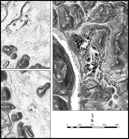
Courtesy Charles Golden
HUMAN-MADE CHANGES: Lidar images of Lacanja Tzeltal (top left) and La Mar (bottom left). In the lidar image of Piedras Negras (right), the ancient architecture has been outlined in black.
page 2 of 2
During the pandemic, Golden and Scherer, along with undergraduates, graduate students and colleagues from Brandeis; Brown University; McMaster University, in Ontario, Canada; the National Autonomous University of Mexico; and the University of Florida, collaborated via teleconferencing and partnered with the region’s local communities to verify data.
The next phase of the research will involve examining the region at ground level, which COVID travel restrictions have prevented so far.
“From the lidar data, we believe we are beginning to understand where people were living, how people were engaging in defense and agriculture, and modifying the landscape,” Golden says. “But all we have are hypotheses until we can get back there and get on the ground.”
Golden and Scherer’s research was funded by the Alphawood Foundation, the National Science Foundation, and the Social Sciences and Humanities Research Council of Canada, as well as the Theodore and Jane Norman Fund for Faculty Scholarship, and the Jane’s Faculty Development Grant from the Latin American, Caribbean and Latinx studies program at Brandeis.