Did the ancient Maya fall because of a drought, or something else?
New research shakes up what we know about the fall of ancient Maya kingdoms
 Courtesy, Charles Golden
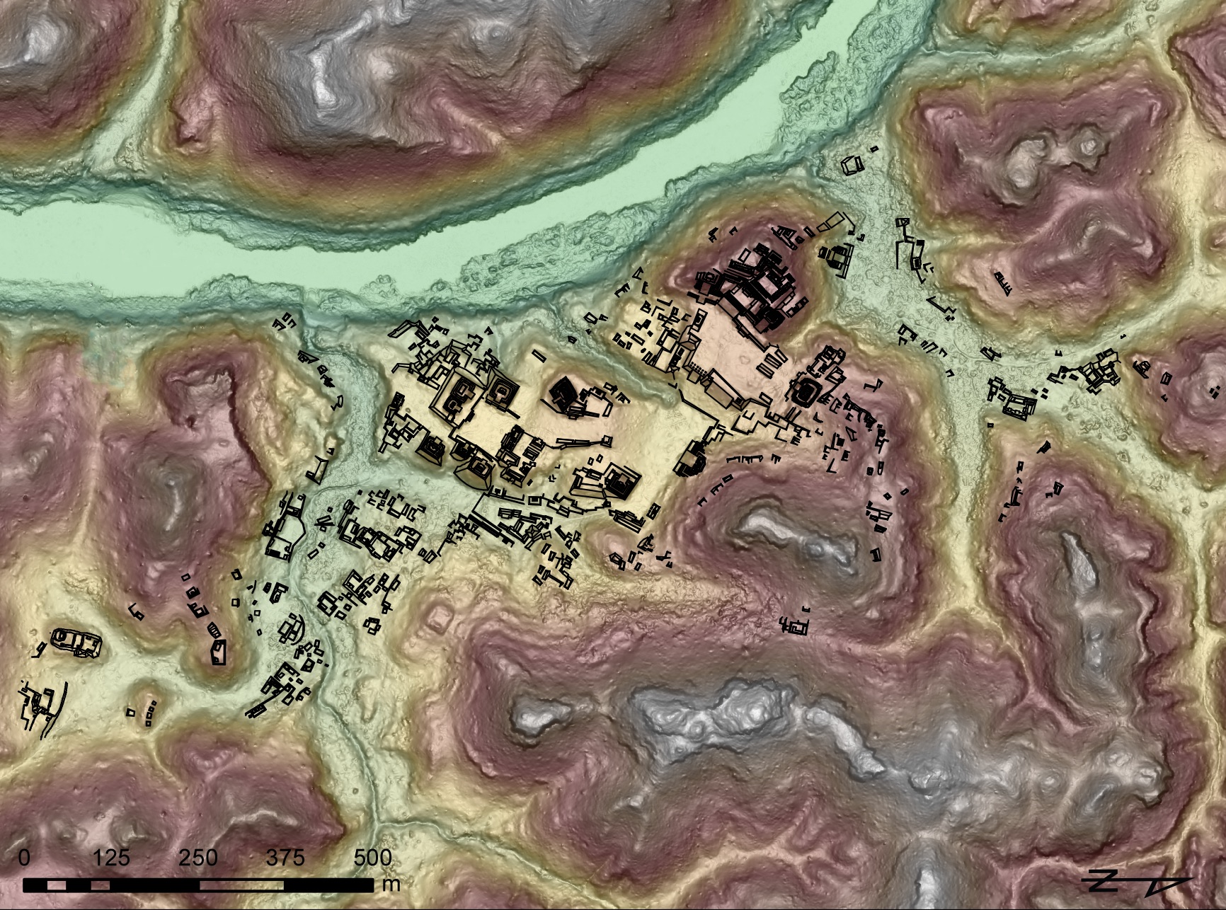
A rendering of Piedras Negras created with lidar data and overlaid with previously mapped architecture.
A severe, prolonged drought created an agricultural crisis that swept all of the Maya kingdoms into history. That's the popular narrative for the fall of the ancient Maya.
New research led by Brandeis associate professor of anthropology Charles Golden and professor Andrew Scherer of Brown University suggests the truth may not be so simple.
The team of researchers found signs that communities in the Western Maya Lowlands likely had an abundance of crops and were not struggling for agricultural resources when Maya civilization fell between the 8th and 9th centuries, and the three main kingdoms in the region were each functioning in very different ways. The discoveries were made with lidar, a remote sensor technology that can create a nearly complete picture of ancient ruins hidden to the naked eye below dense tree canopy.
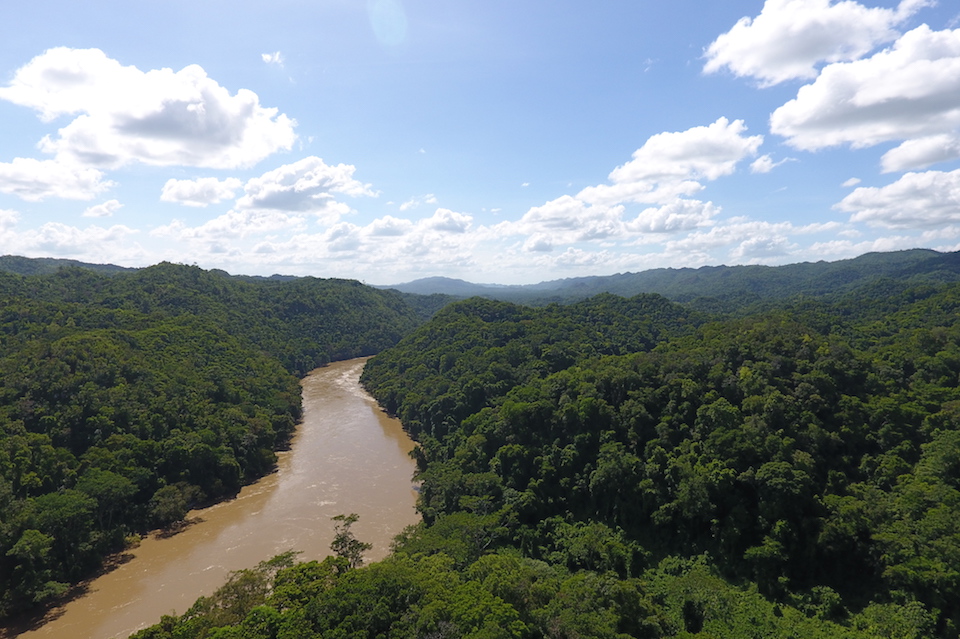
The Usumacinta River at the border of Mexico and Guatemala. Underneath the forest lies the ruins of Piedras Negras.
"What we see is a story about variability," Golden said. "The communities in this area were working and dealing with the challenges of drought, of warfare, of bad kings and good kings in very different ways. It shakes up our picture of who the Maya were."
The research examined three valleys, each containing the capital of an independent kingdom, ancient cities that are known today as Piedras Negras, La Mar and Lacanja Tzeltal. Archaeologists have closely studied parts of the region, but the difficult terrain has left a great deal unknown.
Using lidar flown by the National Center for Airborne Laser Mapping at the University of Houston changed that. The technology involves shooting lasers thousands of times per second from an aircraft towards the ground; the time it takes for each beam to reflect back to the aircraft provides a measure of distance. Most of the beams get stopped by the trees or other obstacles, but enough of them reach the ground to create a complete picture of the landscape.
"Before, we had these intense portraits of a few places. Now, because we were able to pull back and see this landscape, we can see the whole picture," Golden said.
The findings were published in a paper in the academic journal Remote Sensing in October. The lidar analysis of the roughly 20 square mile area found over 5000 structures, many previously unknown.
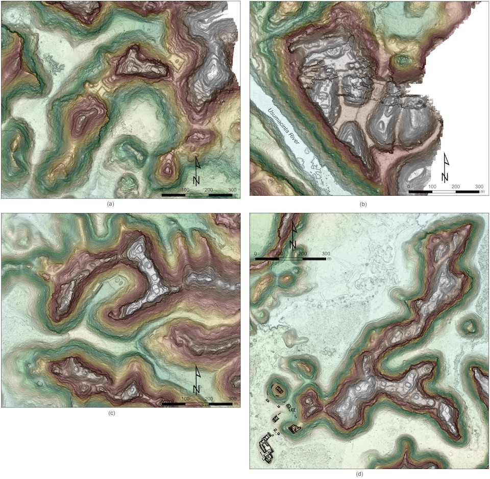
Examples of hilltop settlements: (a) Ahnibal, (b) Macabilero, (c) El Infiernito, (d) Budsilha, with previously mapped architecture overlaid.
The lidar images show Piedras Negras, the largest city in the region, didn't have any nearby agricultural infrastructure, like terraced hillsides or drainage channels. Those features were, however, found in small communities in the countryside surrounding La Mar, where people modified the landscape to buffer themselves against variability in precipitation and to increase food production. Hilltop forts were also found scattered across the landscape, indicating there was likely ongoing conflict between kingdoms, perhaps signs of conflict between these kingdoms and their neighbors as they struggled for control of tribute, trade routes, and the best agricultural resources.
"What all that infrastructure suggests is that people in the countryside in this area were investing their efforts to grow more than enough food to feed themselves. They were likely taking it to be sold in markets in the cities, while the people in the cities were making other choices with their time," Golden said. "It begins to help us imagine how people thought about their daily lives, about how they made choices."
The new findings differ from other regions of ancient Maya previously examined with lidar. Some large ancient cities in Belize were surrounded by terraces built for agriculture, while elsewhere in the Yucatan peninsula there are extensive agricultural landscapes without large cities. The diversity of human-modified landscapes across the Maya world speaks to the many ways that the Maya navigated the complex challenges presented by competing kingdoms and a climate in flux.
"The Maya are often viewed as a cautionary tale about climate change - this great civilization collapses simply because of a drought," Golden said. "Well, that's not quite what happens. They probably didn't collapse because of a drought. And even if drought were a significant problem, everybody was facing that climate change differently."
Golden and Scherer, along with undergraduate, graduate students, and colleagues from Brandeis, Brown University, McMaster University, the National Autonomous University of Mexico, and the University of Florida made the most of their time away from the field during the pandemic, collaborating on the research via teleconferencing, and partnering with members of the local communities in the region to verify the data.
The next phase will involve examining the region up close on the ground, which they could not do because of Covid travel restrictions.
“From the lidar data we believe that we are beginning to understand where people were living, how people were engaging in defense and agriculture and modifying the landscape,” Golden said. “But all we have are hypotheses until we can get back there and get on the ground.”
The research was funded in part by the Alphawood Foundation, the National Science Foundation and the Social Sciences and Humanities Research Council of Canada.
Read more: Ancient Maya kingdom unearthed in a backyard in Mexico
Categories: Humanities and Social Sciences, Research, Science and Technology