Sustainable Working Landscapes
The Sustainable Working Landscapes program promotes community-based research to support a bold vision of conservation and stewardship of forest and farm lands in New England.
"Wildlands & Woodlands: A Vision for the New England Landscape" (Harvard Forest, 2017) proposes that over the next half century a remarkable 85% of the region will remain in forests and farms, while at the same time doubling sustainable wood production and tripling food production.
Vision
This vision calls for active stewardship and productive use of most of the region's landscape (alongside expansive wild reserves), engaging as many people as possible with the land. Increased harvesting of food and wood on conserved private and public land raises exciting opportunities, but also a host of complex challenges. Can we farm, log and hunt on land that is often intermixed with residential development in ways that also promote ecological benefits such as biodiversity, water quality and carbon sequestration?
Program
The Sustainable Working Landscapes program is developing a research "tool kit" to help conservation landowners across New England address these challenges. We are also promoting this active conservation philosophy through workshops, conferences and publications.
The program works at the community level, helping inform the most difficult and sometimes contentious stewardship decisions that conservation landowners have to make:
- Whether to conduct sustainable forestry in woodlands where people love to walk.
- How to expand agricultural production without sacrificing wildlife values.
- Whether to allow bow hunting of deer.
- How to combat invasive pests.
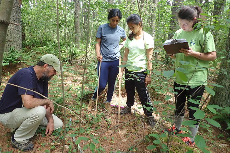
SWL research is designed to engage local residents and schools as citizen scientists, building support for conservation and stewardship.
Places
Sustainable Working Landscapes has established model research programs on conservation lands in Weston, Massachusetts, and in Walden Woods in Concord and Lincoln, Massachusetts, which are detailed on this website. Our hope is that they are both useful to residents and visitors to these places, and helpful for others to design similar programs. We are collaborating at other sites across New England and are happy to help set up projects and build a broader network.
Weston, Massachusetts
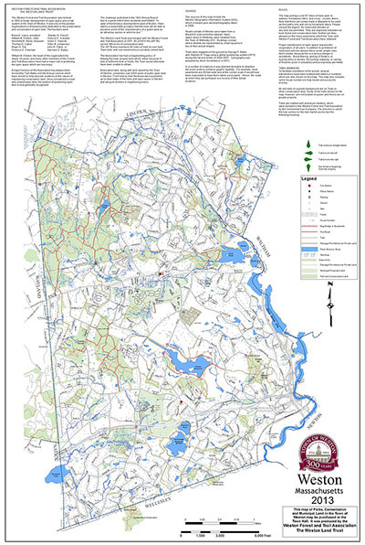 Weston, Massachusetts, a suburb of Boston, has over the past 60 years protected more than 2,000 acres of conservation land — nearly one quarter of the town. Weston has an active conservation land management program, not only maintaining walking trails for passive recreation and keeping fields open for wildlife, but also sponsoring a community farming and forestry program that engages young people with the land and produces fruits and vegetables, maple syrup, firewood and timber.
Weston’s conservation land is managed by the Weston Conservation Commission, along with the land trust Weston Forest and Trail Association and the nonprofit community farm organization Land’s Sake. The land is mostly woodland with a few small open fields — the remnant of a reforested New England pastoral landscape within a leafy residential suburb.
This suburban ecological dynamic, together with a culture of active land management, makes Weston a great site for SWL’s longest-running program. Weston is close to Brandeis University, which provides faculty investigators and student research assistants through its environmental studies program.
Walden Woods
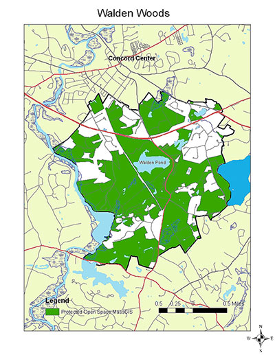 Walden Woods encompasses several thousand acres surrounding Walden Pond in Concord and Lincoln, Massachusetts. It was here that Ralph Waldo Emerson walked and Henry David Thoreau sojourned, making the pond and woods famous.
Because of dry, sandy glacial outwash soils and rocky hills, from the time of English settlement in the 17th century through the height of farmland expansion in the 19th century the area around the pond remained in woodlands managed for firewood and timber, and then increasingly for conservation in the 20th century. Today, much of the Walden Woods area is protected by Walden Pond State Reservation, the Concord Division of Natural Resources, Concord Land Conservation Trust, Lincoln Conservation Commission, Lincoln Land Conservation Trust and Rural Land Foundation, and the Walden Woods Project.
Conservation land owned by a range of government and nonprofit owners, most of it woodland but some open land and farms — intermixed (in varying proportions) with private land, residential development and highways — is typical of southern and central New England. The resulting social and ecological complexity makes Walden Woods an ideal model for the Sustainable Working Landscapes program.
We work closely with conservation landowners to conduct ecological research and to provide information for making sometimes difficult management decisions for this much-loved, much-visited landscape.
Research Tool Kit
We are part of a larger network conducting ecological studies across New England in the complex ecological and social landscapes of New England. This work is part of Wildlands & Woodlands' Stewardship Science program, which uses long-term forest inventory plots spread across the study area.
The inventory plots track long-term changes in the forest, making them increasingly valuable over time. We are particularly interested in ecological divergence between managed and unmanaged parts of the forest — so study areas that have some management activity (such as logging or prescribed burns) but also designated wild reserves are ideal. Once established, the plots also provide a handy resource for other research questions that may arise.